2007 Season
In 2007 we continued the study of the Cama da Vaca and Ancoras
Cama da Vaca
Located south west from Lagos, the Cama da Vaca bay is a shallow secluded bay of 4 ha. Reports of UCH in the area led us to the discover of one piece of artillery and of a stone anchor in the 2006 field school. Being too small for intentional anchorage of vessels and too rocky for any intentional grounding we proceed to study the site from two hypothesis:
A land perspective, in which the materials found were a deposit from a field battery that colapsed into the sea.
A sea perspective, in which the materials found were signs of a shipwreck
After land and underwater visual surveys no more UCH was found and archival research produced no results. The UCH origin is still a mystery.
Âncoras
The study of the anchor site was done with two different goals. First to map and draw all the known anchors. Second to survey the surrounding artefact area and locate more UCH.
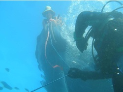
Photomodeler techniques proved ineffectual in the year before and the anchors were drawn with the standard recording method of tape, pencil and underwater slate.
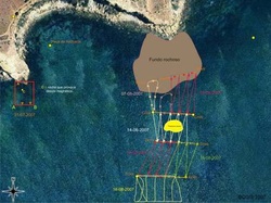
For the survey, due to the unique properties of the site, we had to developed a new underwater survey technique. A team underwater followed the ridges and sandy areas of the site and recorded the information on slates and a team in the surface followed the divers buoy recording the teams positions with a GPS system. Synchronized watches allowed for the data assembly in one coherent map of the area. This was then latter on supplemented by a remote sensing survey of the area.
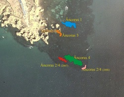
Based upon ethnographic, archaeological and historical data compiled on the site we have located 26 anchors from the classical period to the late 19th century.
Photomodeler techniques proved ineffectual in the year before and the anchors were drawn with the standard recording method of tape, pencil and underwater slate.
For the survey, due to the unique properties of the site, we had to developed a new underwater survey technique. A team underwater followed the ridges and sandy areas of the site and recorded the information on slates and a team in the surface followed the divers buoy recording the teams positions with a GPS system. Synchronized watches allowed for the data assembly in one coherent map of the area. This was then latter on supplemented by a remote sensing survey of the area.
Based upon ethnographic, archaeological and historical data compiled on the site we have located 26 anchors from the classical period to the late 19th century.
